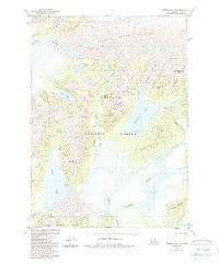
1951 Map of Cordova B-1
USGS Topo · Published 1988About this map
Glacial ice and coal-mining history define this portion of the Chugach National Forest during the mid-20th century. The landscape is dominated by the massive Martin River Glacier and Kushtaka Glacier, which feed a complex network of waterways including the Bering River and Gandil River. Evidence of industrial exploration is visible at Carbon Camp and along the Old Railroad Grade near Bering Lake, reflecting the region's historic attempts to harness its mineral wealth.
Find a feature on this map
49 named features on this map. Tap any name to fly to it.
Don’t see what you’re looking for? This feature index may not catch every label — zoom into the map to look around manually.
Map Details
Editions of this 1951 Cordova B-1 Map
3 editions found
Other maps of this area

1948 · Cordova
USGS Topo · 1:250,000

1950 · Bering Glacier
USGS Topo · 1:250,000

1950 · Cordova B-2
USGS Topo · 1:63,360

1950 · Cordova A-1
USGS Topo · 1:63,360

1950 · Cordova A-2
USGS Topo · 1:63,360

1951 · Bering Glacier
USGS Topo · 1:250,000

1951 · Cordova
USGS Topo · 1:250,000

1951 · Cordova B-1
USGS Topo · 1:63,360

1953 · Cordova A-2
USGS Topo · 1:63,360

1953 · Cordova B-1
USGS Topo · 1:63,360