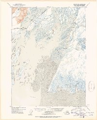
1953 Map of Cordova B-3
USGS Topo · Published 1954About this map
The vast silting landscape of the Copper River Delta dominates this mid-century topographic study, revealing a complex network of shifting sandbars and mudflats where the river meets the Gulf of Alaska. To the north, the Saddlebag Glacier feeds into this hydrological system, while the Martin River joins the primary flow from the east. The map captures a moment of infrastructure development in the Alaskan wilderness, with a road marked as Under Construction and several Bridges spanning the intricate braided channels near Round Island. This region, entirely within the Chugach National Forest, is characterized by its dynamic coastal features like Long Island and Heart Island. Small navigational landmarks, such as the Kokinhenik I beacon and the survey point at VABM 122 Delta, provide fixed reference points amidst the constantly changing geography of Mud and Sand.
Find a feature on this map
20 named features on this map. Tap any name to fly to it.
Don’t see what you’re looking for? This feature index may not catch every label — zoom into the map to look around manually.
Map Details
Editions of this 1953 Cordova B-3 Map
2 editions found

Other maps of this area

1948 · Cordova
USGS Topo · 1:250,000

1950 · Cordova B-2
USGS Topo · 1:63,360

1950 · Cordova A-2
USGS Topo · 1:63,360

1950 · Cordova C-4
USGS Topo · 1:63,360

1951 · Cordova
USGS Topo · 1:250,000

1951 · Cordova B-4
USGS Topo · 1:63,360

1951 · Cordova C-3
USGS Topo · 1:63,360

1952 · Cordova B-3
USGS Topo · 1:63,360

1953 · Cordova A-2
USGS Topo · 1:63,360

1953 · Cordova C-3
USGS Topo · 1:63,360