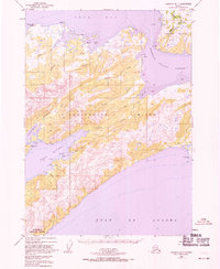
1950 Map of Cordova B-7
USGS Topo · Published 1971About this map
The shoreline of Hinchinbrook Island and the neighboring Hawkins Island dominate this coastal survey, where the waters of Orca Bay meet the open Gulf of Alaska. The interior terrain is defined by a series of drainages, including Anderson Creek and Hunker Creek, while the southwestern tip is designated as the Hinchinbrook Lighthouse Reserve. Early settlement patterns are visible at the village of Nuchek on the shore of Constantine Harbor and the smaller outpost at Garden near Garden Cove. These sites reflect the region's historic maritime dependence and the strategic importance of protected anchorages like Port Etches for navigation and fishing at the entrance to Prince William Sound.
Find a feature on this map
32 named features on this map. Tap any name to fly to it.
Don’t see what you’re looking for? This feature index may not catch every label — zoom into the map to look around manually.
Map Details
Editions of this 1950 Cordova B-7 Map
3 editions found
Other maps of this area

1948 · Cordova
USGS Topo · 1:250,000

1950 · Cordova C-7
USGS Topo · 1:63,360

1950 · Cordova C-6
USGS Topo · 1:63,360

1950 · Cordova B-7
USGS Topo · 1:63,360

1950 · Cordova C-8
USGS Topo · 1:63,360

1951 · Cordova
USGS Topo · 1:250,000

1951 · Cordova B-8
USGS Topo · 1:63,360
1951 · Cordova A-7 and A-8
USGS Topo · 1:63,360

1951 · Cordova B-6
USGS Topo · 1:63,360

1952 · Cordova C-8
USGS Topo · 1:63,360