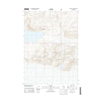
2014 Map of Cordova C-1 NW
USGS Topo · Published 2014About this map
Chugach National Forest encompasses this wilderness area where the massive Miles Glacier dominates the southern landscape. The terrain is defined by the sharp elevations of the Chugach Mountains, which separate the ice fields and glacial lakes that characterize this portion of the Unorganized Borough. At the center of the sheet, Van Cleve Lake sits at the foot of the Van Cleve Glacier, illustrating the dynamic relationship between ice and water in this high-altitude environment. This 2014 survey documents the glacial extents and topographic contours of a remote region where the physical landscape is shaped almost entirely by natural forces, offering a clear record of geological features far from any established settlements or road networks.
Find a feature on this map
9 named features on this map. Tap any name to fly to it.
Don’t see what you’re looking for? This feature index may not catch every label — zoom into the map to look around manually.
Map Details
Editions of this 2014 Cordova C-1 NW Map
This is the sole edition of this map. No revisions or reprints were ever made.
Other maps of this area

1948 · Cordova
USGS Topo · 1:250,000

1951 · Cordova
USGS Topo · 1:250,000

1959 · Cordova C-2
USGS Topo · 1:63,360

1959 · Cordova D-1
USGS Topo · 1:63,360

1959 · Cordova D-2
USGS Topo · 1:63,360

1959 · Cordova C-1
USGS Topo · 1:63,360

1959 · Cordova
USGS Topo · 1:250,000
1994 · Cordova D-2
USGS Topo · 1:63,360
2014 · Cordova C-2 NE
USGS Topo · 1:25,000
2014 · Cordova D-1 SE
USGS Topo · 1:25,000