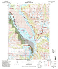
1994 Map of Cordova D-2
USGS Topo · Published 1998About this map
The confluence of the Bremner River and the Copper River dominates this remote landscape, where glacial waters and silted channels carve through the terrain. A cluster of Cabins situated near the riverbanks provides a rare indication of human habitation in a region primarily defined by federal conservation boundaries. To the east, the Wrangell - Saint Elias National Park and its accompanying Wilderness Area protect high-elevation features like Eagle and Hartner peaks.
Find a feature on this map
16 named features on this map. Tap any name to fly to it.
Don’t see what you’re looking for? This feature index may not catch every label — zoom into the map to look around manually.
Map Details
Editions of this 1994 Cordova D-2 Map
This is the sole edition of this map. No revisions or reprints were ever made.
Other maps of this area

1948 · Cordova
USGS Topo · 1:250,000

1950 · Valdez A-3
USGS Topo · 1:63,360

1950 · Cordova D-3
USGS Topo · 1:63,360

1951 · Cordova
USGS Topo · 1:250,000

1951 · Valdez A-1
USGS Topo · 1:63,360

1951 · Cordova C-3
USGS Topo · 1:63,360

1951 · Valdez A-2
USGS Topo · 1:63,360

1952 · Valdez
USGS Topo · 1:250,000

1953 · Cordova C-3
USGS Topo · 1:63,360

1953 · Cordova D-3
USGS Topo · 1:63,360