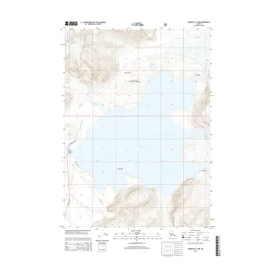
2014 Map of Cordova C-2 NW
USGS Topo · Published 2014About this map
Miles Lake sits at the center of this 2014 survey, where the massive ice flows of Allen Glacier and Miles Glacier meet the powerful current of the Copper River. This landscape is dominated by the dynamic glacial environment within the Chugach National Forest. A critical piece of infrastructure, the Million Dollar Bridge, carries the Copper River Hwy across the water, marking a historic transportation corridor originally carved through this difficult terrain. The map details the transition from the fast-moving Abercrombie Rapids to the calmer waters of Chinaman Slough. Backcountry access is preserved through the Miles Lake Trail, which skirts the western shore of the lake, providing a window into a region defined by moving ice and seasonal river changes.
Find a feature on this map
15 named features on this map. Tap any name to fly to it.
Don’t see what you’re looking for? This feature index may not catch every label — zoom into the map to look around manually.
Map Details
Editions of this 2014 Cordova C-2 NW Map
This is the sole edition of this map. No revisions or reprints were ever made.
Other maps of this area

1948 · Cordova
USGS Topo · 1:250,000

1950 · Cordova D-3
USGS Topo · 1:63,360

1951 · Cordova
USGS Topo · 1:250,000

1951 · Cordova C-3
USGS Topo · 1:63,360

1953 · Cordova C-3
USGS Topo · 1:63,360

1953 · Cordova D-3
USGS Topo · 1:63,360

1959 · Cordova C-2
USGS Topo · 1:63,360

1959 · Cordova D-2
USGS Topo · 1:63,360

1959 · Cordova
USGS Topo · 1:250,000
1994 · Cordova D-2
USGS Topo · 1:63,360