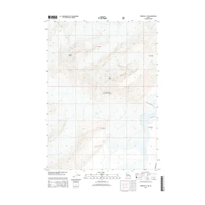
2014 Map of Cordova C-3 NE
USGS Topo · Published 2014About this map
Chugach National Forest dominates this Alaskan landscape, where the massive ice flows of Allen Glacier and Childs Glacier meet the wide braided channels of the Copper River. The terrain is defined by extreme elevation changes, rising from the river valley to the heights of Mount Williams and Mount O'Neel. Transport in this wilderness is limited to the Copper River Hwy and a small network of paths including the Copper River Trail, Childs Glacier North Trail, and Childs Glacier S Trail. These routes follow the natural corridors carved by water and ice, providing access to Abercrombie Cr and the glacial margins. The map illustrates the dynamic interface between moving ice and the river system, capturing a moment in the shifting topography of the Unorganized Borough.
Find a feature on this map
15 named features on this map. Tap any name to fly to it.
Don’t see what you’re looking for? This feature index may not catch every label — zoom into the map to look around manually.
Map Details
Editions of this 2014 Cordova C-3 NE Map
This is the sole edition of this map. No revisions or reprints were ever made.
Other maps of this area

1948 · Cordova
USGS Topo · 1:250,000

1950 · Cordova D-3
USGS Topo · 1:63,360

1951 · Cordova
USGS Topo · 1:250,000

1951 · Cordova C-3
USGS Topo · 1:63,360

1953 · Cordova C-3
USGS Topo · 1:63,360

1953 · Cordova D-3
USGS Topo · 1:63,360

1959 · Cordova C-2
USGS Topo · 1:63,360

1959 · Cordova D-2
USGS Topo · 1:63,360

1959 · Cordova
USGS Topo · 1:250,000
1994 · Cordova D-2
USGS Topo · 1:63,360