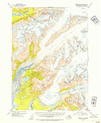
1953 Map of Cordova C-4
USGS Topo · Published 1954About this map
Sheridan Glacier and Scott Glacier dominate this landscape within the Chugach National Forest, where massive ice fields flow toward the coastal lowlands. The 1953 survey captures a transitional environment of active glacial retreat and braided waterways, including the winding Rude River and Glacier River. A single cabin near Bear Lake and a pair of Radio Towers at the edge of the river delta mark the only visible human footprints in a territory defined by shifting ice and water. Numerous crevasses are mapped across the high-elevation ice, reflecting the dangerous and dynamic nature of the terrain during the early 1950s. Smaller drainages like Ibeck Creek and Salmon Creek carve through the lower elevations, highlighting the complex drainage patterns created by the surrounding Shepard Glacier and Sherman Glacier.
Find a feature on this map
14 named features on this map. Tap any name to fly to it.
Don’t see what you’re looking for? This feature index may not catch every label — zoom into the map to look around manually.
Map Details
Editions of this 1953 Cordova C-4 Map
2 editions found

Other maps of this area

1948 · Cordova
USGS Topo · 1:250,000

1950 · Cordova C-4
USGS Topo · 1:63,360

1950 · Cordova D-3
USGS Topo · 1:63,360

1950 · Cordova D-5
USGS Topo · 1:63,360

1951 · Cordova
USGS Topo · 1:250,000

1951 · Cordova B-4
USGS Topo · 1:63,360

1951 · Cordova C-5
USGS Topo · 1:63,360

1951 · Cordova B-5
USGS Topo · 1:63,360

1951 · Cordova C-3
USGS Topo · 1:63,360

1951 · Cordova D-4
USGS Topo · 1:63,360