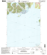
2000 Map of Cordova C-7
USGS Topo · Published 2002About this map
Chugach National Forest dominates the northern shoreline of this maritime study, where the waters of Orca Bay and Port Gravina meet. The landscape is defined by deep inlets and prominent coastal landmarks, including the rugged heights of Knowles 1608 and the navigational importance of the Lighthouse Reserve near Gravina Pt. This era of the region’s history is marked by the vital transit lanes of the Alaska Marine Highway, which connects these remote coastal points. To the south, the northern tip of Hawkins Island at Makarka Point guards the entrance to the bay. Small, secluded waters such as Snug Corner Cove and Two Moon Bay provide natural harbors along a coastline shaped by complex glaciation and tidal geography.
Find a feature on this map
20 named features on this map. Tap any name to fly to it.
Don’t see what you’re looking for? This feature index may not catch every label — zoom into the map to look around manually.
Map Details
Editions of this 2000 Cordova C-7 Map
This is the sole edition of this map. No revisions or reprints were ever made.
Other maps of this area

1948 · Cordova
USGS Topo · 1:250,000

1950 · Cordova C-7
USGS Topo · 1:63,360

1950 · Cordova C-6
USGS Topo · 1:63,360

1950 · Cordova B-7
USGS Topo · 1:63,360

1950 · Cordova D-7
USGS Topo · 1:63,360

1950 · Cordova C-8
USGS Topo · 1:63,360

1951 · Cordova
USGS Topo · 1:250,000

1951 · Cordova D-8
USGS Topo · 1:63,360

1951 · Cordova D-6
USGS Topo · 1:63,360

1951 · Cordova B-8
USGS Topo · 1:63,360