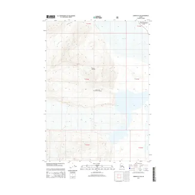
2014 Map of Cordova D-2 SW
USGS Topo · Published 2014About this map
The Chugach Mountains dominate this glacial corridor, where the intersection of protected federal lands and powerful waterways defines the Alaskan wilderness. Positioned at the western edge of Wrangell-Saint Elias National Park and within the Chugach National Forest, the map captures a landscape shaped by massive ice movements. The Allen Glacier and Allen River flow toward the primary drainage of the Copper River, which is marked by intricate water patterns such as Nels Miller Slough. Evidence of human passage through this high-altitude terrain is limited to the Shiels Glacier Trail in the northwest, illustrating the minimal development in this protected region. The map provides a precise record of township boundaries, including t12s r4e and t12s r5e, which are critical for tracking land claims and environmental changes in the Unorganized Borough.
Find a feature on this map
15 named features on this map. Tap any name to fly to it.
Don’t see what you’re looking for? This feature index may not catch every label — zoom into the map to look around manually.
Map Details
Editions of this 2014 Cordova D-2 SW Map
This is the sole edition of this map. No revisions or reprints were ever made.
Other maps of this area

1948 · Cordova
USGS Topo · 1:250,000

1950 · Cordova D-3
USGS Topo · 1:63,360

1951 · Cordova
USGS Topo · 1:250,000

1951 · Cordova C-3
USGS Topo · 1:63,360

1953 · Cordova C-3
USGS Topo · 1:63,360

1953 · Cordova D-3
USGS Topo · 1:63,360

1959 · Cordova C-2
USGS Topo · 1:63,360

1959 · Cordova D-2
USGS Topo · 1:63,360

1959 · Cordova
USGS Topo · 1:250,000
1994 · Cordova D-2
USGS Topo · 1:63,360