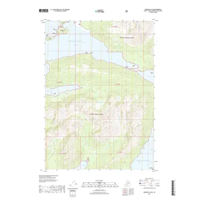
2018 Map of Cordova D-6 SW
USGS Topo · Published 2018About this map
Prince William Sound defines this coastal region of Alaska, where deep inlets and tidal waters meet the steep terrain of the Chugach National Forest. The geography is characterized by several significant embayments, including Port Fidalgo in the north and the tucked-away Whalen Bay to the west. In the southern portion of the quadrangle, Olsen Bay serves as the drainage point for a localized watershed system, collecting the flows of E Fork Olsen Bay Cr and W Fork Olsen Bay Cr. Along the eastern edge, the waters of Port Gravina reach inland, further illustrating the complex, fragmented shoreline of this maritime environment. This 2018 survey provides an exact look at the drainage patterns of Control Cr and the topographical contours of the surrounding wilderness, documenting the hydrography of an area where glacial and oceanic forces have shaped the land.
Find a feature on this map
16 named features on this map. Tap any name to fly to it.
Don’t see what you’re looking for? This feature index may not catch every label — zoom into the map to look around manually.
Map Details
Editions of this 2018 Cordova D-6 SW Map
This is the sole edition of this map. No revisions or reprints were ever made.
Other maps of this area

1948 · Cordova
USGS Topo · 1:250,000

1950 · Cordova C-7
USGS Topo · 1:63,360

1950 · Cordova C-6
USGS Topo · 1:63,360

1950 · Cordova D-7
USGS Topo · 1:63,360

1951 · Cordova
USGS Topo · 1:250,000

1951 · Cordova D-6
USGS Topo · 1:63,360

1952 · Cordova D-7
USGS Topo · 1:63,360

1953 · Cordova C-6
USGS Topo · 1:63,360
1953 · Cordova C-7
USGS Topo · 1:63,360

1953 · Cordova D-6
USGS Topo · 1:63,360