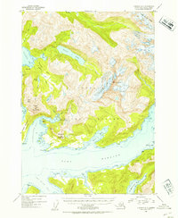
1952 Map of Cordova D-7
USGS Topo · Published 1954About this map
Port Fidalgo and its surrounding inlets define this mid-century survey of the Alaskan coast. The map illustrates a landscape where steep peaks like Billygoat Mountain and Mt Denson rise directly from the water's edge, broken by deep fjords such as Landlocked Bay and St Matthews Bay. This era shows the maritime and industrial character of the region, featuring a Mine located near Whalen Bay and the settlement at Galena Bay.
Find a feature on this map
38 named features on this map. Tap any name to fly to it.
Don’t see what you’re looking for? This feature index may not catch every label — zoom into the map to look around manually.
Map Details
Editions of this 1952 Cordova D-7 Map
2 editions found

Other maps of this area

1948 · Cordova
USGS Topo · 1:250,000

1950 · Cordova C-7
USGS Topo · 1:63,360

1950 · Cordova C-6
USGS Topo · 1:63,360

1950 · Cordova D-7
USGS Topo · 1:63,360

1950 · Cordova C-8
USGS Topo · 1:63,360

1951 · Cordova
USGS Topo · 1:250,000

1951 · Cordova D-8
USGS Topo · 1:63,360

1951 · Cordova D-6
USGS Topo · 1:63,360

1951 · Valdez A-6
USGS Topo · 1:63,360

1952 · Valdez
USGS Topo · 1:250,000