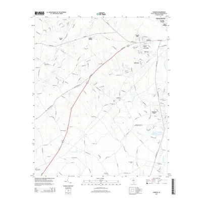
2014 Map of Cordova
USGS Topo · Published 2014About this map
Cordova and its surrounding agricultural and residential settlements appear here during the mid-2010s, showing a landscape defined by the drainage of the North Fork Edisto River. The map highlights a dense network of local community landmarks, including numerous rural cemeteries and churches such as Saint George Baptist Church Cem and the Wesley Grove United Methodist Church Cem. The terrain is marked by extensive wetlands and watercourses, notably Snake Swamp, Cooper Swamp, and Dry Swamp, which shape the road patterns and property boundaries of Orangeburg County. Aviation history and local industry are represented by the Dry Swamp Airport and the County Hatchery Pond near the eastern border. This survey provides genealogists with a modern record of family-named sites like the Smoak Family Cem, grounding historical lineage in the physical geography of South Carolina's coastal plain.
Find a feature on this map
151 named features on this map. Tap any name to fly to it.
Don’t see what you’re looking for? This feature index may not catch every label — zoom into the map to look around manually.
Map Details
Editions of this 2014 Cordova Map
This is the sole edition of this map. No revisions or reprints were ever made.
Other maps of this area

1919 · Bamberg
USGS Topo · 1:48,000

1920 · Bamberg
USGS Topo · 1:62,500

1920 · Orangeburg
USGS Topo · 1:48,000

1921 · Orangeburg
USGS Topo · 1:62,500

1943 · Bamberg
USGS Topo · 1:62,500

1943 · Orangeburg
USGS Topo · 1:125,000

1943 · Orangeburg
USGS Topo · 1:62,500

1946 · Woodford
USGS Topo · 1:62,500

1946 · St. Matthews
USGS Topo · 1:62,500

1954 · Augusta
USGS Topo · 1:250,000