
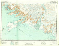
1948 Map of Cordova
USGS Topo · Published 1957About this map
The Copper River Delta dominates this coastal survey, where the intricate network of the Alaganik Slough and Pete Dahl Slough meet the Gulf of Alaska. Inland, the map documents the established village at Tatitlek and the coastal settlement of Katalla, situated near the mouth of the Katalla River. The landscape is a complex of islands and deep-water inlets, including Hinchinbrook Island and Hawkins Island, which shield the approaches to Orca Inlet.
Find a feature on this map
125 named features on this map. Tap any name to fly to it.
Don’t see what you’re looking for? This feature index may not catch every label — zoom into the map to look around manually.
Map Details
Editions of this 1948 Cordova Map
2 editions found
Other maps of this area

1946 · Blying Sound
USGS Topo · 1:250,000

1948 · Middleton Island
USGS Topo · 1:250,000

1950 · Middleton Island
USGS Topo · 1:250,000

1950 · McCarthy A-8
USGS Topo · 1:63,360

1950 · Bering Glacier
USGS Topo · 1:250,000

1950 · Icy Bay
USGS Topo · 1:250,000

1950 · Valdez A-3
USGS Topo · 1:63,360

1950 · Cordova B-2
USGS Topo · 1:63,360

1950 · Cordova C-7
USGS Topo · 1:63,360

1950 · Cordova A-1
USGS Topo · 1:63,360