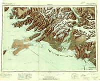
1951 Map of Cordova
USGS Topo · Published 1951About this map
Cordova and its complex coastal surroundings serve as the anchor for this 1951 coastal survey, which details the maritime and aviation infrastructure of the post-war era. The port's development is evident near Orca Inlet, supported by the Cordova Airport and the nearby settlement of Orca. The map reveals a landscape defined by deep glacial fjords and sheltered bays like Port Fidalgo and Orca Bay, where historical fishing and transport patterns shaped local settlements.
Find a feature on this map
184 named features on this map. Tap any name to fly to it.
Don’t see what you’re looking for? This feature index may not catch every label — zoom into the map to look around manually.
Map Details
Editions of this 1951 Cordova Map
3 editions found

Other maps of this area

1946 · Blying Sound
USGS Topo · 1:250,000

1948 · Cordova
USGS Topo · 1:250,000

1948 · Middleton Island
USGS Topo · 1:250,000

1950 · Middleton Island
USGS Topo · 1:250,000

1950 · McCarthy A-8
USGS Topo · 1:63,360

1950 · Bering Glacier
USGS Topo · 1:250,000

1950 · Icy Bay
USGS Topo · 1:250,000

1950 · Valdez A-3
USGS Topo · 1:63,360

1950 · Cordova B-2
USGS Topo · 1:63,360

1950 · Cordova C-7
USGS Topo · 1:63,360