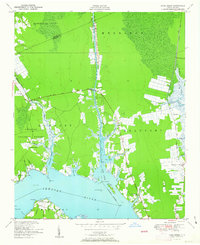
1951 Map of Core Creek
USGS Topo · Published 1951About this map
Adams Creek Canal serves as the central artery of this coastal landscape, bisecting the terrain as part of the Intracoastal Waterway system. The map documents a period where water-based transit and small coastal settlements defined eastern North Carolina, showing the intricate network of creeks such as Harlowe Creek, Eastman Creek, and Ware Creek that feed into the Newport River. Dense wooded areas of the Croatan National Forest dominate the western portion, while small communities like Crab Point Village and Live Oak Grove occupy the drier elevations near the shore.
Find a feature on this map
51 named features on this map. Tap any name to fly to it.
Don’t see what you’re looking for? This feature index may not catch every label — zoom into the map to look around manually.
Map Details
Editions of this 1951 Core Creek Map
3 editions found

Other maps of this area

1949 · Beaufort
USGS Topo · 1:24,000

1949 · Merrimon
USGS Topo · 1:24,000

1949 · Newport
USGS Topo · 1:24,000

1949 · Williston
USGS Topo · 1:24,000

1949 · Harkers Island
USGS Topo · 1:24,000

1949 · South River
USGS Topo · 1:24,000

1949 · Mansfield
USGS Topo · 1:24,000

1949 · Cherry Point
USGS Topo · 1:24,000

1949 · Core Creek
USGS Topo · 1:24,000

1950 · South River
USGS Topo · 1:24,000