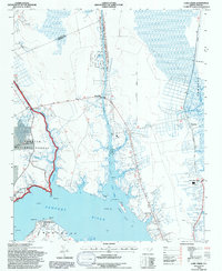
1994 Map of Core Creek
USGS Topo · Published 1997About this map
Core Creek and the surrounding coastal plains of Carteret County are defined by a complex network of man-made and natural waterways. This 1990s landscape illustrates the strategic importance of the Adams Creek Canal and the Intracoastal Waterway, which connect the Newport River to points north. The terrain is a mixture of wetlands and timberland, much of it protected within the Croatan National Forest. Local history is anchored by numerous country churches, including Graham Chapel and Live Oak Grove Ch, which serve the small communities and rural intersections. The eastern portion of the sheet shows the expansive waters of the Straits and the North River, where coastal features like White Rock and Turtle Rock dot the mudflats. Settlement patterns here are tied to the water, visible in small hamlets like North River Corner and the waterfront docks of Crab Point Village.
Find a feature on this map
53 named features on this map. Tap any name to fly to it.
Don’t see what you’re looking for? This feature index may not catch every label — zoom into the map to look around manually.
Map Details
Editions of this 1994 Core Creek Map
2 editions found
Other maps of this area

1949 · Beaufort
USGS Topo · 1:24,000

1949 · Merrimon
USGS Topo · 1:24,000

1949 · Newport
USGS Topo · 1:24,000

1949 · Williston
USGS Topo · 1:24,000

1949 · Harkers Island
USGS Topo · 1:24,000

1949 · South River
USGS Topo · 1:24,000

1949 · Mansfield
USGS Topo · 1:24,000

1949 · Cherry Point
USGS Topo · 1:24,000

1949 · Core Creek
USGS Topo · 1:24,000

1950 · South River
USGS Topo · 1:24,000