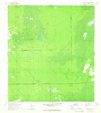
1958 Map of Corkscrew SW
USGS Topo · Published 1966About this map
Corkscrew Swamp Sanctuary dominates the northeastern reaches of this mid-century Florida landscape, preserving a vast wetland ecosystem at the intersection of the Lee Co Collier Co line. The terrain is characterized by intricate drainage patterns and seasonal water bodies, including the Bird Rookery Swamp and Horseshoe Marsh. Unlike many urbanizing regions of the era, this survey depicts a wilderness largely devoid of permanent structures, defined instead by the natural rhythm of the Corkscrew Swamp. A notable human intrusion appears in the southern portion of the sheet, where a road is marked as Under Construction, signaling the early stages of infrastructure development that would eventually bridge these remote interior wetlands with the growing coastal communities.
Find a feature on this map
7 named features on this map. Tap any name to fly to it.
Don’t see what you’re looking for? This feature index may not catch every label — zoom into the map to look around manually.
Map Details
Editions of this 1958 Corkscrew SW Map
4 editions found
Other maps of this area

1956 · West Palm Beach
USGS Topo · 1:250,000

1957 · West Palm Beach
USGS Topo · 1:250,000

1958 · West Palm Beach
USGS Topo · 1:250,000

1958 · Corkscrew SE
USGS Topo · 1:24,000

1958 · Bonita Springs
USGS Topo · 1:24,000

1958 · Corkscrew NW
USGS Topo · 1:24,000

1958 · Estero
USGS Topo · 1:24,000

1958 · Belle Meade NE
USGS Topo · 1:24,000

1958 · Belle Meade NW
USGS Topo · 1:24,000

1958 · Corkscrew SW
USGS Topo · 1:24,000
Featured Places
- Bonita National Golf & Country Club, FL
- Village Walk, FL
- Quail West, FL
- Bonita Landing, FL
- Hunters Ridge, FL