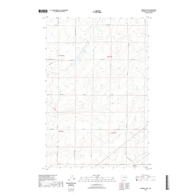
2020 Map of Cormana Lake
USGS Topo · Published 2020About this map
Cormana Lake and the winding course of Duck Cr define this section of the Lincoln County plateau, where water management and agriculture have long shaped the landscape. The small settlement of Downs sits in the southeastern corner near the confluence of local drainage ways, including Coal Cr, which flows through the area south of Coal Coulee Rd E. The map reveals a highly structured grid of section lines and rural roads, many bearing family names like Nitschke Rd, Doggett Rd, and Salo Rd, reflecting a heritage of homesteading and land ownership. The presence of Swenson Lake further west illustrates the seasonal or semi-permanent wetlands characteristic of this high-desert environment, interconnected by a network of thoroughfares such as Tebow Rd and Duck Lake Rd E.
Find a feature on this map
32 named features on this map. Tap any name to fly to it.
Don’t see what you’re looking for? This feature index may not catch every label — zoom into the map to look around manually.
Map Details
Editions of this 2020 Cormana Lake Map
This is the sole edition of this map. No revisions or reprints were ever made.
Other maps of this area

1953 · Ritzville
USGS Topo · 1:250,000

1959 · Ritzville
USGS Topo · 1:250,000

1965 · Ritzville
USGS Topo · 1:250,000

1968 · Sylvan Lake
USGS Topo · 1:24,000

1968 · Coffeepot Lake
USGS Topo · 1:24,000

1969 · Rocklyn SW
USGS Topo · 1:24,000

1969 · Harrington
USGS Topo · 1:24,000

1969 · Cormana Lake
USGS Topo · 1:24,000

1969 · Lamona
USGS Topo · 1:24,000
1969 · Rocklyn SE
USGS Topo · 1:24,000