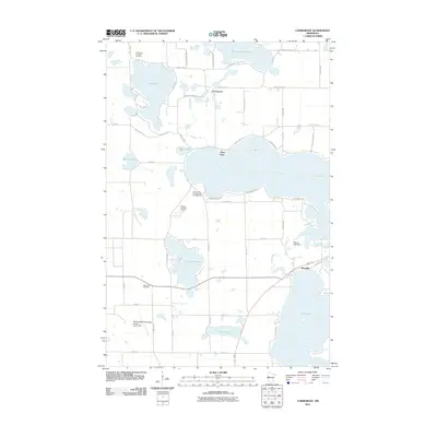
2010 Map of Cormorant
USGS Topo · Published 2010About this map
Big Cormorant Lake and Lake Lizzie anchor this landscape in western Becker County, where a dense network of lakeside communities and seasonal residences reflects the area's long-standing draw for recreation and settlement. The small community of Cormorant sits central to the upper lake system, while Dunvilla marks the southeastern corridor near the Pelican River. For those researching local roots, the map identifies the Cormorant Lutheran Cemetery near Lake Ida and the Scambler Cemetery further south, providing clear reference points for family histories. The presence of Pelican Lake Dam and various beach developments, such as Gosslee Beach Rd and Sherbrooke Beach Rd, underscores how the shoreline was carved into specific neighborhoods by the early 21st century. Infrastructure like the Pelican Rapids Municipal Airport-Lyons Field and the Rolling Hills Golf Course further illustrate the transition of this lake-strewn terrain into a developed regional hub.
Find a feature on this map
56 named features on this map. Tap any name to fly to it.
Don’t see what you’re looking for? This feature index may not catch every label — zoom into the map to look around manually.
Map Details
Editions of this 2010 Cormorant Map
This is the sole edition of this map. No revisions or reprints were ever made.
Other maps of this area

1912 · Vergas
USGS Topo · 1:62,500

1914 · Pelican Rapids
USGS Topo · 1:62,500

1915 · Vergas
USGS Topo · 1:62,500

1917 · Pelican Rapids
USGS Topo · 1:62,500

1953 · Fargo
USGS Topo · 1:250,000

1953 · Brainerd
USGS Topo · 1:250,000

1956 · Fargo
USGS Topo · 1:250,000

1957 · Brainerd
USGS Topo · 1:250,000

1958 · Brainerd
USGS Topo · 1:250,000
1959 · Audubon
USGS Topo · 1:24,000