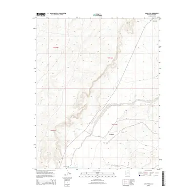
2014 Map of Cornfields
USGS Topo · Published 2014About this map
The Pueblo Colorado Valley serves as the central geographic feature of this high-desert region, where the Pueblo Colorado Wash cuts through the landscape. The settlement of Cornfields is established near the intersection of several Bureau of Indian Affairs routes, including Bia-15 and Bia-15a. Further north, the community of Burnside sits near the northern boundary, while Mai Dagi occupies the southwestern portion of the map. This terrain is characterized by a network of drainage systems and isolated water sources such as Tsaaadidosi Spring and Mail Carrier Spring, which were vital for sustaining the small communities and livestock in this arid environment. The map details a sophisticated grid of rural roads and county routes, like Co Road 416, that connect these remote habitations and seasonal grazing areas.
Find a feature on this map
21 named features on this map. Tap any name to fly to it.
Don’t see what you’re looking for? This feature index may not catch every label — zoom into the map to look around manually.
Map Details
Editions of this 2014 Cornfields Map
This is the sole edition of this map. No revisions or reprints were ever made.
Other maps of this area

1886 · Fort Defiance
USGS Topo · 1:250,000

1892 · Fort Defiance
USGS Topo · 1:250,000

1954 · Gallup
USGS Topo · 1:250,000

1958 · Gallup
USGS Topo · 1:250,000

1959 · Gallup
USGS Topo · 1:250,000

1962 · Gallup
USGS Topo · 1:250,000

1967 · Gallup
USGS Topo · 1:250,000
1972 · Steamboat Canyon
USGS Topo · 1:24,000
1972 · Greasewood
USGS Topo · 1:24,000
1972 · Ganado Mesa SW
USGS Topo · 1:24,000