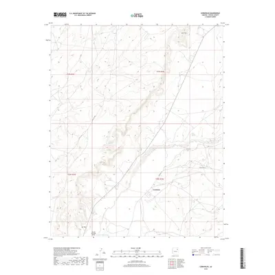
2018 Map of Cornfields
USGS Topo · Published 2018About this map
Cornfields serves as the primary point of settlement in this high-desert landscape, positioned along the edge of the Pueblo Colorado Valley. The terrain is defined by the ephemeral winding path of the Pueblo Colorado Wash, which dictates the placement of local infrastructure and traditional grazing lands. Historically significant water sources, such as Mail Carrier Spring and Tsagagidisi Spring, are documented alongside landforms including Gah Chidi and Mai Dagi. The map illustrates a network of essential travel corridors, featuring Indian Rte 151 and Indian Rte 9005, which connect the isolated homesteads and community structures of the Fort Defiance Agency. The 2018 survey detail provides a clear record of the contemporary Navajo Nation landscape, showing how modern county and Indian routes navigate the ancient topography.
Find a feature on this map
14 named features on this map. Tap any name to fly to it.
Don’t see what you’re looking for? This feature index may not catch every label — zoom into the map to look around manually.
Map Details
Editions of this 2018 Cornfields Map
This is the sole edition of this map. No revisions or reprints were ever made.
Other maps of this area

1886 · Fort Defiance
USGS Topo · 1:250,000

1892 · Fort Defiance
USGS Topo · 1:250,000

1954 · Gallup
USGS Topo · 1:250,000

1958 · Gallup
USGS Topo · 1:250,000

1959 · Gallup
USGS Topo · 1:250,000

1962 · Gallup
USGS Topo · 1:250,000

1967 · Gallup
USGS Topo · 1:250,000
1972 · Steamboat Canyon
USGS Topo · 1:24,000
1972 · Greasewood
USGS Topo · 1:24,000
1972 · Ganado Mesa SW
USGS Topo · 1:24,000