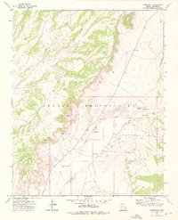
1972 Map of Cornfields
USGS Topo · Published 1976About this map
Cornfields and the surrounding landscape of the Navajo Indian Reservation are defined by an intricate network of desert water sources and drainage systems as they appeared in the early 1970s. The topography is dominated by the Colorado Pueblo Wash, which serves as a central artery through a terrain marked by Sand Dunes and prominent elevations like Gah Chidi and Mai Dagi. For genealogists and local historians, this map provides a rare record of specific named water features and family-associated landmarks. Numerous wells and springs are documented across the desert floor, including the Hatahley Bijay Well, Hosteen Begay Well, and Joe Friday Well, alongside the historically evocative Mail Carrier Spring. These labels reflect the essential relationship between the residents and the scarce water resources of the Apache County high desert.
Find a feature on this map
15 named features on this map. Tap any name to fly to it.
Don’t see what you’re looking for? This feature index may not catch every label — zoom into the map to look around manually.
Map Details
Editions of this 1972 Cornfields Map
This is the sole edition of this map. No revisions or reprints were ever made.
Other maps of this area

1886 · Fort Defiance
USGS Topo · 1:250,000

1892 · Fort Defiance
USGS Topo · 1:250,000

1954 · Gallup
USGS Topo · 1:250,000

1958 · Gallup
USGS Topo · 1:250,000

1959 · Gallup
USGS Topo · 1:250,000

1962 · Gallup
USGS Topo · 1:250,000

1967 · Gallup
USGS Topo · 1:250,000
1972 · Steamboat Canyon
USGS Topo · 1:24,000
1972 · Greasewood
USGS Topo · 1:24,000
1972 · Ganado Mesa SW
USGS Topo · 1:24,000