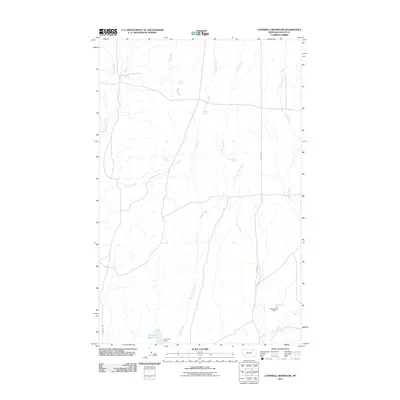
2011 Map of Cornwell Reservoir
USGS Topo · Published 2011About this map
Cornwell Reservoir and its associated Cornwell Dam anchor the southern portion of this high plains landscape in Montana's Valley County. The terrain is defined by a dendritic network of drainage systems, where Wolf Creek, Crooked Creek, and Spring Creek carve paths through the open range. This 2011 survey reveals a workspace of livestock management and water conservation, evidenced by the numerous named water sources critical for ranching in an arid climate, such as Hunt Spring, Burke Spring, and Alkali Spring. Transportation is limited to functional routes like Cornwell Rd and the Jensen Trl, which navigate between the creek beds and the Maraschino Dam to the east. The map provides a detailed view of the West Fork Cherry Creek as it joins the larger drainage system, illustrating the vital role of these seasonal watercourses in the regional geography.
Find a feature on this map
15 named features on this map. Tap any name to fly to it.
Don’t see what you’re looking for? This feature index may not catch every label — zoom into the map to look around manually.
Map Details
Editions of this 2011 Cornwell Reservoir Map
This is the sole edition of this map. No revisions or reprints were ever made.
Other maps of this area

1919 · Boundary
USGS Topo · 1:125,000

1943 · Glasgow
USGS Topo · 1:125,000

1954 · Glasgow
USGS Topo · 1:250,000

1957 · Glasgow
USGS Topo · 1:250,000

1958 · Glasgow
USGS Topo · 1:250,000

1969 · Cornwell Reservoir
USGS Topo · 1:24,000

1969 · Chapman Coulee NE
USGS Topo · 1:24,000
1969 · Tampico
USGS Topo · 1:24,000
1969 · Chapman Coulee
USGS Topo · 1:24,000
1969 · Tampico NE
USGS Topo · 1:24,000