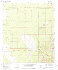
1981 Map of Corona De Tucson
USGS Topo · Published 1981About this map
The residential pocket of Corona de Tucson sits at the base of rising terrain as it appeared in the early 1980s, flanked by the managed conservation lands of the Santa Rita Experimental Range and Wildlife Area. This landscape is defined by the transition from the high desert floor to the foothills of the Santa Rita Mountains, where industrial and military footprints meet open range. To the northwest, the Sahuarita Air Force Range occupies a significant portion of the valley floor, while a remote Landing Strip and a Radio Tower suggest the specialized infrastructure required in this arid environment.
Find a feature on this map
15 named features on this map. Tap any name to fly to it.
Don’t see what you’re looking for? This feature index may not catch every label — zoom into the map to look around manually.
Map Details
Editions of this 1981 Corona De Tucson Map
2 editions found
Other maps of this area

1904 · Patagonia
USGS Topo · 1:125,000

1904 · Tucson
USGS Topo · 1:125,000

1905 · Patagonia
USGS Topo · 1:125,000

1905 · Tucson
USGS Topo · 1:125,000

1926 · Helvetia
USGS Topo · 1:62,500

1948 · Tucson
USGS Topo · 1:62,500

1956 · Nogales
USGS Topo · 1:250,000

1956 · Tucson
USGS Topo · 1:250,000

1957 · Tucson
USGS Topo · 1:62,500

1957 · Rincon Valley
USGS Topo · 1:62,500