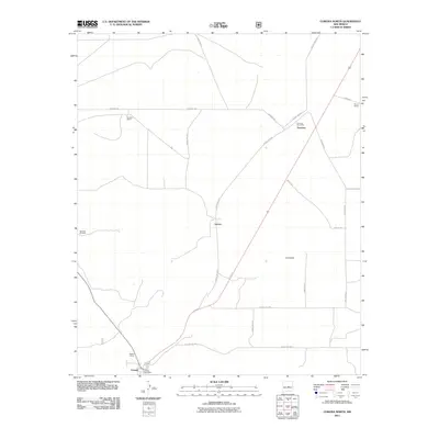
2011 Map of Corona North
USGS Topo · Published 2011About this map
Torrance and Corona anchor this high-desert landscape in Lincoln County, where the road network reflects a pattern of isolated ranching and rural mail delivery. The presence of both the Torrance Post Office and the Corona Post Office highlights these sites as vital community nodes in a region characterized by vast distances between settlements. Family-named landmarks such as Bagley Ranch, Brunson Ranch, and Sharp Ranch underscore the legacy of cattle ranching that has long sustained the area. Water remains a critical resource, evidenced by the Shartzer Windmill, a essential feature for survival in this arid terrain. The map also traces smaller locales like Varney and Camaleon, connected by a web of local routes including Torrance Rd and Holloman Rd.
Find a feature on this map
22 named features on this map. Tap any name to fly to it.
Don’t see what you’re looking for? This feature index may not catch every label — zoom into the map to look around manually.
Map Details
Editions of this 2011 Corona North Map
This is the sole edition of this map. No revisions or reprints were ever made.
Other maps of this area

1954 · Fort Sumner
USGS Topo · 1:250,000

1958 · Fort Sumner
USGS Topo · 1:250,000

1980 · Corona
USGS Topo · 1:100,000

1981 · Gallo Spring Canyon
USGS Topo · 1:24,000

1981 · Rough Mountain
USGS Topo · 1:24,000

1981 · Pino Mountain
USGS Topo · 1:24,000

1981 · Camaleon Draw West
USGS Topo · 1:24,000
1981 · Duran
USGS Topo · 1:24,000
1981 · Cedarvale NE
USGS Topo · 1:24,000

1981 · Corona South
USGS Topo · 1:24,000