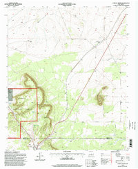
1995 Map of Corona North
USGS Topo · Published 1998About this map
The Southern Pacific railroad corridor defines the transit and settlement pattern of this high-desert region during the mid-1990s. The village of Corona anchors the southern portion of the map, situated near the Rodeo Grounds and the county line dividing Torrance and Lincoln counties. To the north, the small settlement of Torrance sits along the rail line, while the western landscape is dominated by the protected lands of the Cibola National Forest. The map is a record of ranching infrastructure and water management in an arid environment, featuring numerous named tanks like Lee Tank and North Simpson Tank, alongside the Shartzer Windmill. High points such as Camaleon overlook the Camaleon Draw, illustrating the relationship between the drainage systems and the few established homesteads like Brunson Ranch and Bagley Ranch that dot the territory.
Find a feature on this map
20 named features on this map. Tap any name to fly to it.
Don’t see what you’re looking for? This feature index may not catch every label — zoom into the map to look around manually.
Map Details
Editions of this 1995 Corona North Map
This is the sole edition of this map. No revisions or reprints were ever made.
Other maps of this area

1954 · Fort Sumner
USGS Topo · 1:250,000

1958 · Fort Sumner
USGS Topo · 1:250,000

1980 · Corona
USGS Topo · 1:100,000

1981 · Gallo Spring Canyon
USGS Topo · 1:24,000

1981 · Rough Mountain
USGS Topo · 1:24,000

1981 · Pino Mountain
USGS Topo · 1:24,000

1981 · Camaleon Draw West
USGS Topo · 1:24,000
1981 · Duran
USGS Topo · 1:24,000
1981 · Cedarvale NE
USGS Topo · 1:24,000

1981 · Corona South
USGS Topo · 1:24,000