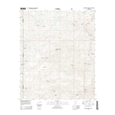
2014 Map of Coronado Mountain
USGS Topo · Published 2014About this map
Coronado Mountain and Grey Peak dominate this high-desert terrain within the Apache National Forest, where the landscape is defined by a complex network of canyons and drainage systems. The small settlement of Granville sits near the eastern edge along US Hwy-191, serving as a rare point of habitation in a region primarily used for ranching and resource management. The intricate water infrastructure, marked by numerous named tanks and springs like the Deerhead Ranch Tanks and Tule Springs, reveals how essential water management is for life and livestock in this environment. From the Painted Bluffs to the deep recesses of Cistern Canyon, the map illustrates a transition between prominent peaks and the winding draws of Whitewater Creek and Knight Canyon. Researchers can trace old land divisions such as Spur Cross and follow the rugged boundary between Graham and Greenlee counties.
Find a feature on this map
103 named features on this map. Tap any name to fly to it.
Don’t see what you’re looking for? This feature index may not catch every label — zoom into the map to look around manually.
Map Details
Editions of this 2014 Coronado Mountain Map
This is the sole edition of this map. No revisions or reprints were ever made.
Other maps of this area

1902 · Clifton
USGS Topo · 1:62,500

1913 · Morenci
USGS Topo · 1:125,000

1915 · Morenci
USGS Topo · 1:125,000

1954 · Clifton
USGS Topo · 1:250,000

1957 · Clifton
USGS Topo · 1:250,000

1958 · Clifton
USGS Topo · 1:250,000

1962 · Clifton
USGS Topo · 1:250,000

1962 · Clifton
USGS Topo · 1:62,500

1962 · Bryce Mountain
USGS Topo · 1:62,500
1967 · Bee Canyon
USGS Topo · 1:24,000