
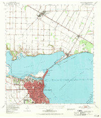
1951 Map of Corpus Christi
USGS Topo · Published 1952About this map
Corpus Christi anchors this mid-century coastal survey, showcasing a landscape defined by industrial expansion and the deepening of maritime infrastructure. The intricate network of the Corpus Christi Ship Channel and the Turning Basin at the mouth of the Nueces River reveal the city's role as a primary Texas port. Extensive dredging projects are noted, including the Tule Lake Channel and the Encinal Channel, facilitating movement through the shallow waters of Nueces Bay and Corpus Christi Bay.
Find a feature on this map
54 named features on this map. Tap any name to fly to it.
Don’t see what you’re looking for? This feature index may not catch every label — zoom into the map to look around manually.
Map Details
Editions of this 1951 Corpus Christi Map
2 editions found
Other maps of this area

1924 · Petronilla
USGS Topo · 1:62,500

1925 · Robstown
USGS Topo · 1:62,500

1925 · Aransas Pass
USGS Topo · 1:62,500

1925 · Oso Creek
USGS Topo · 1:62,500

1925 · Corpus Christi
USGS Topo · 1:62,500

1950 · Corpus Christi
USGS Topo · 1:250,000

1951 · Portland
USGS Topo · 1:24,000

1951 · Corpus Christi
USGS Topo · 1:24,000

1951 · Crane Islands NW
USGS Topo · 1:24,000

1951 · Oso Creek NW
USGS Topo · 1:24,000