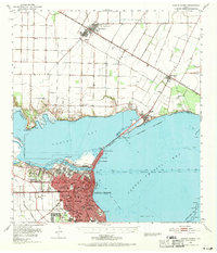
1951 Map of Corpus Christi
USGS Topo · Published 1969About this map
Corpus Christi serves as the industrial and maritime hub of the Texas Gulf Coast in this mid-century survey, defined by its complex network of dredged channels and rail lines. The city's growth is visible through residential developments like Alta Vista and educational institutions including Miller High Sch and Corpus Christi Academy. Across Nueces Bay, linked by the Nueces Bay Causeway, the landscape shifts toward the agriculture and energy production of San Patricio County.
Find a feature on this map
55 named features on this map. Tap any name to fly to it.
Don’t see what you’re looking for? This feature index may not catch every label — zoom into the map to look around manually.
Map Details
Editions of this 1951 Corpus Christi Map
2 editions found
Other maps of this area

1924 · Petronilla
USGS Topo · 1:62,500

1925 · Robstown
USGS Topo · 1:62,500

1925 · Aransas Pass
USGS Topo · 1:62,500

1925 · Oso Creek
USGS Topo · 1:62,500

1925 · Corpus Christi
USGS Topo · 1:62,500

1950 · Corpus Christi
USGS Topo · 1:250,000

1951 · Portland
USGS Topo · 1:24,000

1951 · Corpus Christi
USGS Topo · 1:24,000

1951 · Corpus Christi
USGS Topo · 1:62,500

1951 · Crane Islands NW
USGS Topo · 1:24,000