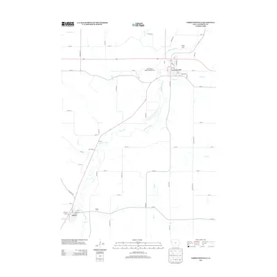
2013 Map of Correctionville
USGS Topo · Published 2013About this map
The Little Sioux River carves a winding path through this corner of Woodbury County, serving as the primary geographic anchor for the settlements of Correctionville and Anthon. The landscape is defined by the river’s broad floodplain and the numerous tributaries that feed it, including Threemile Cr, Pierson Cr, and Bacon Cr. To the west of Correctionville, the Sioux Bend Public Hunting Area and Walling River Access indicate the importance of the river corridor for local recreation and conservation.
Find a feature on this map
56 named features on this map. Tap any name to fly to it.
Don’t see what you’re looking for? This feature index may not catch every label — zoom into the map to look around manually.
Map Details
Editions of this 2013 Correctionville Map
This is the sole edition of this map. No revisions or reprints were ever made.
Other maps of this area

1954 · Fort Dodge
USGS Topo · 1:250,000

1957 · Fort Dodge
USGS Topo · 1:250,000

1958 · Fort Dodge
USGS Topo · 1:250,000

1969 · Holstein SW
USGS Topo · 1:24,000

1969 · Pierson
USGS Topo · 1:24,000

1969 · Correctionville NW
USGS Topo · 1:24,000

1969 · Correctionville
USGS Topo · 1:24,000
1969 · Kingsley
USGS Topo · 1:24,000

1969 · Cushing
USGS Topo · 1:24,000
1969 · Oto
USGS Topo · 1:24,000