
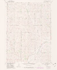
1969 Map of Holstein SW
USGS Topo · Published 1971About this map
Maple River drainage patterns define the topography of this western Iowa landscape, where the Woodbury and Ida County line divides the rolling agricultural terrain. The map captures a moment in the late 1960s when rural life was anchored by landmarks like St Pauls Ch in the north and St Marys Cem to the south. Transportation and industry are concentrated in the southeastern corner, where the Chicago and North Western railroad corridor runs parallel to the river valley near a local Gravel Pit. Numerous smaller waterways, including Big Creek, Aldrich Creek, and Moorhead Creek, carve through the townships of Morgan, Maple, Liston, and Garfield. This survey is particularly detailed regarding land boundaries, featuring fine red dashed lines that indicate specific fence and field lines as they appeared during aerial photography in 1968.
Find a feature on this map
15 named features on this map. Tap any name to fly to it.
Don’t see what you’re looking for? This feature index may not catch every label — zoom into the map to look around manually.
Map Details
Editions of this 1969 Holstein SW Map
2 editions found
Other maps of this area

1954 · Fort Dodge
USGS Topo · 1:250,000

1957 · Fort Dodge
USGS Topo · 1:250,000

1958 · Fort Dodge
USGS Topo · 1:250,000

1967 · Holstein
USGS Topo · 1:24,000

1967 · Battle Creek
USGS Topo · 1:24,000

1969 · Danbury
USGS Topo · 1:24,000

1969 · Mapleton
USGS Topo · 1:24,000

1969 · Correctionville
USGS Topo · 1:24,000

1969 · Cushing
USGS Topo · 1:24,000
1969 · Correctionville SE
USGS Topo · 1:24,000