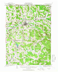
1929 Map of Corry
USGS Topo · Published 1958About this map
The industrial and transportation hub of Corry sits at the intersection of the Pennsylvania RR and the Erie RR, serving as a focal point for this 1929 survey of northwestern Pennsylvania. The landscape is defined by the headwaters of several significant drainages, including French Creek, Brokenstraw Creek, and the East Branch Oil Creek. These waterways supported a dense network of rural communities such as Columbus, Spartansburg, and Bear Lake, which grew alongside the rail lines and regional thoroughfares like the Roosevelt Highway.
Find a feature on this map
106 named features on this map. Tap any name to fly to it.
Don’t see what you’re looking for? This feature index may not catch every label — zoom into the map to look around manually.
Map Details
Editions of this 1929 Corry Map
2 editions found
Other maps of this area

1904 · Chautaqua
USGS Topo · 1:62,500

1905 · Clymer
USGS Topo · 1:62,500

1913 · North East
USGS Topo · 1:62,500

1915 · North East
USGS Topo · 1:62,500

1926 · Youngsville
USGS Topo · 1:62,500

1927 · Townville
USGS Topo · 1:48,000

1927 · Tidioute
USGS Topo · 1:48,000

1927 · Titusville
USGS Topo · 1:62,500

1929 · Corry
USGS Topo · 1:48,000

1929 · Youngsville
USGS Topo · 1:62,500