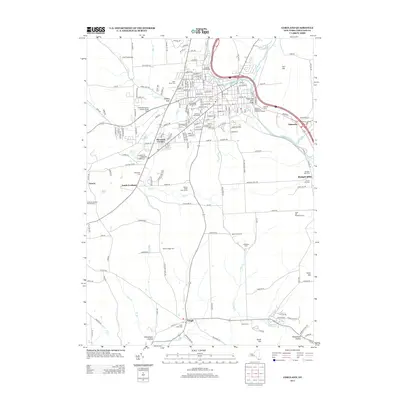
2013 Map of Cortland
USGS Topo · Published 2013About this map
The confluence of the W Br Tioughnioga River and E Br Tioughnioga River anchors the regional layout of this New York interior, where the Tioughnioga River flows past the developed center of Cortland. Higher education and local infrastructure are prominent, with the Suny College at Cortland campus situated near the western edge of the city. Transportation corridors such as I-81 and the New York Susquehanna and Western RR trace the valley floors, connecting industrial and residential zones.
Find a feature on this map
52 named features on this map. Tap any name to fly to it.
Don’t see what you’re looking for? This feature index may not catch every label — zoom into the map to look around manually.
Map Details
Editions of this 2013 Cortland Map
This is the sole edition of this map. No revisions or reprints were ever made.
Other maps of this area

1898 · Moravia
USGS Topo · 1:62,500

1900 · Dryden
USGS Topo · 1:62,500

1902 · Moravia
USGS Topo · 1:62,500

1903 · Cortland
USGS Topo · 1:62,500

1903 · Harford
USGS Topo · 1:62,500

1906 · Catatonk
USGS Topo · 1:125,000

1942 · Groton
USGS Topo · 1:24,000

1943 · Groton
USGS Topo · 1:31,680
1943 · Sempronius
USGS Topo · 1:31,680
1944 · Homer
USGS Topo · 1:31,680