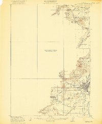
1921 Map of Corvallis
USGS Topo · Published 1921About this map
Corvallis serves as a major hub in the Willamette Valley during the early 1920s, anchored by the expansive grounds of the Oregon Agricultural College. The landscape is defined by the winding course of the Marys River and Muddy Creek, which irrigate the agricultural lands west of the Willamette River. In this era, the Southern Pacific railroad and the Pacific Highway West Side provided the primary arteries for commerce and travel, connecting the valley settlements. The map reveals a dense network of rural infrastructure, including numerous family-named landmarks like Smith Hill and Oak Hill. Local education is decentralized, with several schoolhouses such as Union School, Evergreen School, and Savage School serving the surrounding farming communities. This preliminary edition also captures the transition from surveyed terrain to a large Preliminary Edition Unsurveyed Area to the west, highlighting the ongoing work of the U.S. Geological Survey in mapping the Oregon Coast Range foothills.
Find a feature on this map
34 named features on this map. Tap any name to fly to it.
Don’t see what you’re looking for? This feature index may not catch every label — zoom into the map to look around manually.
Map Details
Editions of this 1921 Corvallis Map
5 editions found
Other maps of this area

1911 · Inavale
USGS Topo · 1:31,680

1912 · Halsey
USGS Topo · 1:62,500

1913 · Philomath
USGS Topo · 1:31,680

1913 · Oakville
USGS Topo · 1:31,680

1913 · Wells
USGS Topo · 1:31,680

1914 · Independence
USGS Topo · 1:31,680

1914 · Soap Creek
USGS Topo · 1:31,680

1916 · Albany
USGS Topo · 1:62,500

1917 · Salem
USGS Topo · 1:62,500

1921 · Corvallis
USGS Topo · 1:62,500