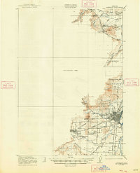
1921 Map of Corvallis
USGS Topo · Published 1948About this map
Corvallis serves as the focal point of this valley survey, showcasing the early layout of Oregon State College and the growing residential grid near the Marys River. The town of Philomath stands to the west, connected by the Southern Pacific Highway and the Southern Pacific rail line. A significant portion of the western territory remains an Unsurveyed Area, contrasting with the detailed mapping of the Willamette Valley floor where agriculture and early education appear well-established through numerous rural schoolhouses like Union School and Soap Creek School. Local landmarks such as the Corvallis Reservoir at the foot of Bald Hill and the Mt Union Cemetery provide essential reference points for genealogists tracing family locations. The waterway network is complex, featuring the Kiger Island Channel and the winding course of Muddy Creek through the southern lowlands.
Find a feature on this map
39 named features on this map. Tap any name to fly to it.
Don’t see what you’re looking for? This feature index may not catch every label — zoom into the map to look around manually.
Map Details
Editions of this 1921 Corvallis Map
5 editions found
Other maps of this area

1911 · Inavale
USGS Topo · 1:31,680

1912 · Halsey
USGS Topo · 1:62,500

1913 · Philomath
USGS Topo · 1:31,680

1913 · Oakville
USGS Topo · 1:31,680

1913 · Wells
USGS Topo · 1:31,680

1914 · Independence
USGS Topo · 1:31,680

1914 · Soap Creek
USGS Topo · 1:31,680

1916 · Albany
USGS Topo · 1:62,500

1917 · Salem
USGS Topo · 1:62,500

1921 · Corvallis
USGS Topo · 1:62,500