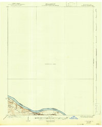
1931 Map of Corydon
USGS Topo · Published 1932About this map
Brandenburg serves as a focal point along the southern bank of the Ohio River in this pre-war survey, which captures the riverine border between Harrison and Meade counties. The landscape is defined by the sharp transition from the water's edge to the bluffs above, marked by features such as Hamilton Hill and the incision of Big Gully. While much of the quadrangle is noted as an Unsurveyed Area, the mapped portion reveals the essential infrastructure of the era, including the L & N railroad and the Oak Grove Sch. Waterways like Doe Run and Flippins Run feed into the main river channel near Buttermilk Falls, illustrating the drainage patterns that shaped local settlement at Moravia and surrounding hillsides.
Find a feature on this map
14 named features on this map. Tap any name to fly to it.
Don’t see what you’re looking for? This feature index may not catch every label — zoom into the map to look around manually.
Map Details
Editions of this 1931 Corydon Map
4 editions found
Other maps of this area

1909 · Kosmosdale
USGS Topo · 1:48,000

1912 · Kosmosdale
USGS Topo · 1:62,500

1928 · Hardinsburg
USGS Topo · 1:48,000

1931 · Hardinsburg
USGS Topo · 1:62,500

1931 · Corydon
USGS Topo · 1:62,500

1936 · Vine Grove
USGS Topo · 1:62,500

1939 · Georgetown
USGS Topo · 1:24,000

1941 · Ekron
USGS Topo · 1:62,500

1943 · Vine Grove
USGS Topo · 1:62,500

1944 · Corydon West
USGS Topo · 1:24,000