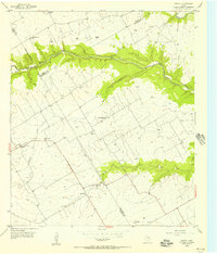
1955 Map of Coryell
USGS Topo · Published 1956About this map
The Middle Bosque River and its meandering tributaries define the transition between Bosque, Coryell, and McLennan Counties in this mid-century survey. The landscape is primarily agrarian, marked by a high density of windmills providing water for livestock and small rural settlements. Small communities like Coryell, Osage, and Mosheim serve as anchors for the surrounding countryside, connected by an emerging network of unimproved and medium-duty roads.
Find a feature on this map
23 named features on this map. Tap any name to fly to it.
Don’t see what you’re looking for? This feature index may not catch every label — zoom into the map to look around manually.
Map Details
Editions of this 1955 Coryell Map
2 editions found
Other maps of this area

1888 · Meridian
USGS Topo · 1:125,000

1892 · Temple
USGS Topo · 1:125,000

1892 · Waco
USGS Topo · 1:125,000

1894 · Meridian
USGS Topo · 1:125,000

1894 · Gatesville
USGS Topo · 1:125,000

1920 · Waco
USGS Topo · 1:125,000

1931 · Valley Mills
USGS Topo · 1:62,500

1931 · Mc Gregor
USGS Topo · 1:62,500

1947 · Oglesby
USGS Topo · 1:24,000

1947 · Gatesville East
USGS Topo · 1:24,000