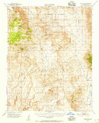
1951 Map of Coso Peak
USGS Topo · Published 1956About this map
Coso sits at the heart of this high-desert landscape, where the extraction of precious metals and the management of water resources defined the mid-century economy. Surveyed shortly after World War II, the map reveals an environment transitioning into heavy military use, with the Naval Ordnance Test Station and its rifle range encompassing much of the terrain. Mineral interests remain prominent through the presence of the Silver Spoon Mine, Mariposa Mine, and El Conejo Mine, while the scarcity of water is evidenced by the density of named springs such as Indian Gardens Spr and China Gardens Spr. To the east, the Argus Range rises above the Etcheron Valley, while southern features like Wild Horse Mesa and Louisiana Butte anchor the desolate topography. The inclusion of isolated dwellings like Dead End Cabin and remote outposts like Junction Ranch provides a window into the survival and logistics of the California desert during this era.
Find a feature on this map
45 named features on this map. Tap any name to fly to it.
Don’t see what you’re looking for? This feature index may not catch every label — zoom into the map to look around manually.
Map Details
Editions of this 1951 Coso Peak Map
3 editions found

Other maps of this area

1908 · Ballarat
USGS Topo · 1:250,000

1913 · Ballarat
USGS Topo · 1:250,000

1915 · Searles Lake
USGS Topo · 1:250,000

1947 · Trona
USGS Topo · 1:250,000

1948 · Trona
USGS Topo · 1:250,000

1948 · Death Valley
USGS Topo · 1:250,000

1949 · Trona
USGS Topo · 1:62,500

1950 · Trona
USGS Topo · 1:62,500

1950 · Darwin
USGS Topo · 1:62,500

1951 · Darwin
USGS Topo · 1:62,500