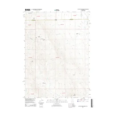
2014 Map of Cotton Thomas Basin
USGS Topo · Published 2014About this map
Cotton Thomas Basin sits at the heart of this high-elevation landscape in the northwest corner of Box Elder County, where the Grouse Creek Mountains dominate the southern terrain. This 2014 survey reveals a rugged geography defined by deep basins and drainages, marked by several early mining or water-conveyance infrastructure points like the Phelan Tunnel and Sullivan Tunnel near Pipe Spring Gulch. The northern border of the map tracks the state line between Idaho and Utah, showing the transition from Middle Mountain down through Granite Pass into the southern basins.
Find a feature on this map
39 named features on this map. Tap any name to fly to it.
Don’t see what you’re looking for? This feature index may not catch every label — zoom into the map to look around manually.
Map Details
Editions of this 2014 Cotton Thomas Basin Map
This is the sole edition of this map. No revisions or reprints were ever made.
Other maps of this area

1954 · Pocatello
USGS Topo · 1:250,000

1954 · Brigham City
USGS Topo · 1:250,000

1958 · Pocatello
USGS Topo · 1:250,000

1958 · Brigham City
USGS Topo · 1:250,000

1959 · Cotton Thomas Basin
USGS Topo · 1:62,500

1959 · Yost
USGS Topo · 1:62,500

1962 · Brigham City
USGS Topo · 1:250,000

1968 · Almo
USGS Topo · 1:24,000
1968 · Blue Hill
USGS Topo · 1:24,000

1968 · Lyman Pass
USGS Topo · 1:24,000