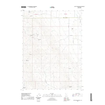
2020 Map of Cotton Thomas Basin
USGS Topo · Published 2020About this map
Middle Mountain and the Goose Creek Mountains anchor this high-elevation corner where the Utah-Idaho state line divides Box Elder and Cassia counties. The landscape is defined by its drainage systems, with Granite Cr and Pine Cr flowing north across the border while Basin Cr and Mahogany Cr carve through the southern basins. A notable concentration of industrial history is found near Pipe Spring Gulch, where the Phelan Tunnel and Sullivan Tunnel remain as evidence of previous subterranean exploration.
Find a feature on this map
34 named features on this map. Tap any name to fly to it.
Don’t see what you’re looking for? This feature index may not catch every label — zoom into the map to look around manually.
Map Details
Editions of this 2020 Cotton Thomas Basin Map
This is the sole edition of this map. No revisions or reprints were ever made.
Other maps of this area

1954 · Pocatello
USGS Topo · 1:250,000

1954 · Brigham City
USGS Topo · 1:250,000

1958 · Pocatello
USGS Topo · 1:250,000

1958 · Brigham City
USGS Topo · 1:250,000

1959 · Cotton Thomas Basin
USGS Topo · 1:62,500

1959 · Yost
USGS Topo · 1:62,500

1962 · Brigham City
USGS Topo · 1:250,000

1968 · Almo
USGS Topo · 1:24,000
1968 · Blue Hill
USGS Topo · 1:24,000

1968 · Lyman Pass
USGS Topo · 1:24,000