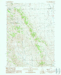
1990 Map of Cotton Thomas Basin
USGS Topo · Published 1990About this map
Emigrant Trail tracks through the high country of the Goose Creek Mountains, crossing the state line where Idaho and Utah meet. This 1990 provisional study documents a landscape defined by its mining heritage and high-altitude passes, notably at Granite Pass between Middle Mountain and the southern ranges. The western slopes are particularly scarred by early extraction efforts, including the Dolly Clark Mine and Skoro Mine, alongside a series of underground works such as the Midway and Phelan tunnels.
Find a feature on this map
29 named features on this map. Tap any name to fly to it.
Don’t see what you’re looking for? This feature index may not catch every label — zoom into the map to look around manually.
Map Details
Editions of this 1990 Cotton Thomas Basin Map
This is the sole edition of this map. No revisions or reprints were ever made.
Other maps of this area

1954 · Pocatello
USGS Topo · 1:250,000

1954 · Brigham City
USGS Topo · 1:250,000

1958 · Pocatello
USGS Topo · 1:250,000

1958 · Brigham City
USGS Topo · 1:250,000

1959 · Cotton Thomas Basin
USGS Topo · 1:62,500

1959 · Yost
USGS Topo · 1:62,500

1962 · Brigham City
USGS Topo · 1:250,000

1968 · Almo
USGS Topo · 1:24,000
1968 · Blue Hill
USGS Topo · 1:24,000

1968 · Lyman Pass
USGS Topo · 1:24,000