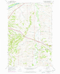
1967 Map of Cottonwood Creek
USGS Topo · Published 1977About this map
The Yellowstone River cuts across the northwest corner of this Yellowstone County landscape, where the Burlington Northern railroad and the Huntley Main Canal follow the river corridor. A complex network of drainage systems, including Pryor Creek, Cottonwood Creek, and Three Wolf Creek, defines the terrain as it rises toward the southern plateau. Much of the southern half of the sheet is governed by the Crow Indian Reservation Boundary, illustrating the intersection of tribal lands with the expanding agricultural and transportation infrastructure of the mid-20th century.
Find a feature on this map
22 named features on this map. Tap any name to fly to it.
Don’t see what you’re looking for? This feature index may not catch every label — zoom into the map to look around manually.
Map Details
Editions of this 1967 Cottonwood Creek Map
2 editions found
Other maps of this area

1893 · Huntley
USGS Topo · 1:125,000

1954 · Billings
USGS Topo · 1:250,000

1956 · Rattlesnake Butte
USGS Topo · 1:24,000

1956 · Huntley
USGS Topo · 1:24,000

1956 · Billings East
USGS Topo · 1:24,000

1957 · Billings
USGS Topo · 1:250,000

1958 · Billings
USGS Topo · 1:250,000

1967 · Worden
USGS Topo · 1:24,000

1967 · Soda Springs NW
USGS Topo · 1:24,000

1967 · Cottonwood Creek
USGS Topo · 1:24,000