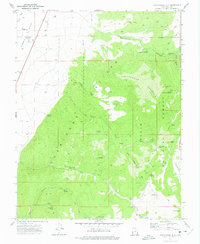
1971 Map of Cottonwood Mtn
USGS Topo · Published 1975About this map
Parowan Valley meets the dramatic rising face of the Hurricane Cliffs on this 1970s survey of southern Utah. The map documents a landscape defined by its water sources, with numerous Springs and named catchments like the Upper Cottonwood Troughs and Lower Cottonwood Troughs providing critical infrastructure for cattle and land management within the Dixie National Forest. A network of pack trails and jeep trails navigates the steep grades through Mineral Canyon and Cottonwood Canyon, illustrating the era’s reliance on rugged access routes for forest administration and resource scouting.
Find a feature on this map
43 named features on this map. Tap any name to fly to it.
Don’t see what you’re looking for? This feature index may not catch every label — zoom into the map to look around manually.
Map Details
Editions of this 1971 Cottonwood Mtn Map
This is the sole edition of this map. No revisions or reprints were ever made.
Other maps of this area

1885 · Beaver
USGS Topo · 1:250,000

1886 · Kanab
USGS Topo · 1:250,000

1953 · Richfield
USGS Topo · 1:250,000

1953 · Cedar City
USGS Topo · 1:250,000

1958 · Richfield
USGS Topo · 1:250,000

1958 · Cedar City
USGS Topo · 1:250,000

1958 · Minersville
USGS Topo · 1:62,500

1962 · Cedar City
USGS Topo · 1:250,000

1971 · Buckhorn Flat
USGS Topo · 1:24,000

1971 · Paragonah
USGS Topo · 1:24,000