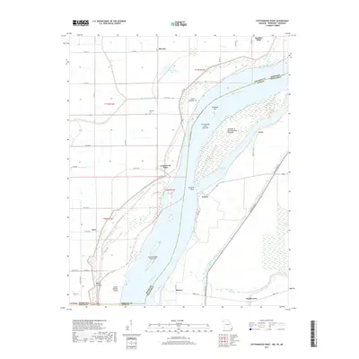
2017 Map of Cottonwood Point
USGS Topo · Published 2017About this map
Mississippi River dynamics define this borderland where Missouri, Tennessee, and Arkansas meet. The landscape is shaped by the river's shifting course, evidenced by features like Island Number 18, Island Number Twenty, and the Midway Crevasse. Near the riverbanks, small communities such as Cottonwood Point, Heloise, and Ayers sit amidst a network of low-lying wetlands and oxbow formations like Half-Moon Lake. The proximity to the water is reflected in landmarks like Skullbone Bar and Eagle Bar, which illustrate the constant deposition and erosion of the riverbed. Inland, the transition to agricultural land is marked by scattered settlements including McCarty, Midway, and Bradleytown. Local history is anchored by the Hickman Cem and Taylor Cem, while the Obion River and Big Slough drain the Tennessee side of the floodplain, highlighting the complex hydrology of the tri-state area.
Find a feature on this map
53 named features on this map. Tap any name to fly to it.
Don’t see what you’re looking for? This feature index may not catch every label — zoom into the map to look around manually.
Map Details
Editions of this 2017 Cottonwood Point Map
This is the sole edition of this map. No revisions or reprints were ever made.
Other maps of this area

1939 · Hales Point
USGS Topo · 1:62,500

1939 · Caruthersville
USGS Topo · 1:62,500

1939 · Blytheville
USGS Topo · 1:62,500

1940 · Hayti
USGS Topo · 1:62,500

1951 · Caruthersville
USGS Topo · 1:62,500

1952 · Hales Point
USGS Topo · 1:62,500

1955 · Hayti
USGS Topo · 1:62,500

1955 · Blytheville
USGS Topo · 1:62,500

1956 · Dyersburg
USGS Topo · 1:250,000

1956 · Blytheville
USGS Topo · 1:250,000