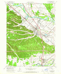
1965 Map of Cottonwood
USGS Topo · Published 1966About this map
The Sacramento River meanders through the heart of this mid-1960s survey, separating the Stillwater Plains from the residential and industrial growth of Anderson. This era shows a landscape transitioning between agricultural roots and modern infrastructure, evidenced by the proximity of the Shasta District Fairgrounds to the long-standing Southern Pacific rail line. A Calif-Oregon Tr Historical Marker near the river bank points to the area's deep history as a travel corridor, while Dredge Tailings along the western hillsides mark the physical legacy of resource extraction.
Find a feature on this map
79 named features on this map. Tap any name to fly to it.
Don’t see what you’re looking for? This feature index may not catch every label — zoom into the map to look around manually.
Map Details
Editions of this 1965 Cottonwood Map
3 editions found
Other maps of this area

1890 · Red Bluff
USGS Topo · 1:250,000

1894 · Red Bluff
USGS Topo · 1:250,000

1901 · Redding
USGS Topo · 1:125,000

1932 · Olinda
USGS Topo · 1:31,680

1935 · Olinda
USGS Topo · 1:31,680

1944 · Redding
USGS Topo · 1:62,500

1944 · Tuscan Buttes
USGS Topo · 1:62,500

1946 · Redding
USGS Topo · 1:62,500

1947 · Tuscan Buttes
USGS Topo · 1:62,500

1947 · Anderson
USGS Topo · 1:62,500