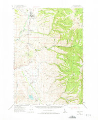
1954 Map of Council
USGS Topo · Published 1975About this map
Council serves as the focal point of this mid-century Idaho landscape, situated along the Weiser River where the Union Pacific railroad parallels the water. The map documents a rural society in transition, noting several former community hubs such as Cottonwood Sch (Aban'd) and Hillsdale School (Aban'd) alongside the active Middle Fork School. To the west, Mesa and its accompanying Mesa Siding highlight the importance of rail transport for local fruit and agricultural output.
Find a feature on this map
62 named features on this map. Tap any name to fly to it.
Don’t see what you’re looking for? This feature index may not catch every label — zoom into the map to look around manually.
Map Details
Editions of this 1954 Council Map
2 editions found
Other maps of this area

1894 · Squaw Creek
USGS Topo · 1:125,000

1897 · Weiser
USGS Topo · 1:125,000

1911 · Meadows
USGS Topo · 1:125,000

1953 · Smiths Ferry
USGS Topo · 1:62,500

1954 · Council
USGS Topo · 1:62,500

1954 · New Meadows
USGS Topo · 1:62,500

1954 · Cascade
USGS Topo · 1:62,500

1955 · Baker
USGS Topo · 1:250,000

1957 · Cambridge
USGS Topo · 1:62,500

1957 · Crane Creek Reservoir
USGS Topo · 1:62,500