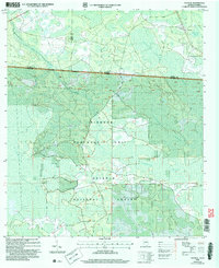
2006 Map of Council
USGS Topo · Published 2007About this map
Council sits near the Georgia-Florida state line, serving as a primary point of human settlement in a landscape dominated by the vast wetlands of the Pinhook Swamp. This 2006 revision, based on earlier mid-century topography, illustrates the complex boundary where Clinch and Echols Counties in Georgia meet Columbia County in Florida. The southern portion of the map is defined by the Osceola National Forest and the Purchase Unit, highlighting the conservation of this ecological corridor. The terrain is a network of slow-moving water and dense vegetation, with White Arm Swamp and Little Suwannee Creek carving through the low-lying reaches. Distinctive linear features like the Roosevelt Line Grade and the Watson Line cut across the natural drainage patterns, likely reflecting historical forestry or surveying efforts that attempted to organize this saturated wilderness.
Find a feature on this map
12 named features on this map. Tap any name to fly to it.
Don’t see what you’re looking for? This feature index may not catch every label — zoom into the map to look around manually.
Map Details
Editions of this 2006 Council Map
This is the sole edition of this map. No revisions or reprints were ever made.
Other maps of this area

1954 · Valdosta
USGS Topo · 1:250,000

1955 · Council
USGS Topo · 1:24,000

1955 · Fargo SW
USGS Topo · 1:24,000

1956 · Sargent
USGS Topo · 1:24,000

1958 · Valdosta
USGS Topo · 1:250,000

1959 · Valdosta
USGS Topo · 1:250,000

1967 · Strange Island
USGS Topo · 1:24,000

1967 · Sargent
USGS Topo · 1:24,000

1967 · Fargo
USGS Topo · 1:24,000

1968 · Needmore
USGS Topo · 1:24,000