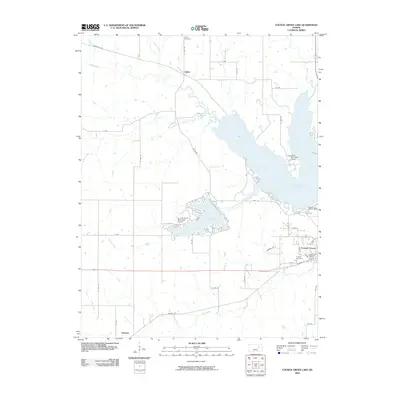
2009 Map of Council Grove Lake
USGS Topo · Published 2009About this map
Council Grove serves as the focal point of this Morris County region, situated where the Neosho River and Elm Creek meet. By the early 21st century, the landscape is defined by significant water management projects, most notably Council Grove Lake and the smaller City Reservoir. The northern reaches include the small settlement of Kelso, while Helmick is located to the south. Local history is anchored by established burial grounds like Greenwood Cemetery and Calvary Cemetery on the outskirts of the main town. The surrounding terrain is a grid of section roads, including Parkerville Rd and Kelso Rd, which connect the rural farmsteads to the aviation hub at Council Grove Municipal Airport and the recreational grounds at White Memorial Camp. Small waterways such as Gilmore Creek and Canning Creek feed into the reservoir system, illustrating the area's transition from river-bottom agriculture to a managed watershed and residential center.
Find a feature on this map
44 named features on this map. Tap any name to fly to it.
Don’t see what you’re looking for? This feature index may not catch every label — zoom into the map to look around manually.
Map Details
Editions of this 2009 Council Grove Lake Map
This is the sole edition of this map. No revisions or reprints were ever made.
Other maps of this area

1885 · Eskridge
USGS Topo · 1:125,000

1889 · Parkerville
USGS Topo · 1:125,000

1889 · Eskridge
USGS Topo · 1:125,000

1894 · Eskridge
USGS Topo · 1:125,000

1894 · Parkerville
USGS Topo · 1:125,000

1955 · Hutchinson
USGS Topo · 1:250,000

1959 · Hutchinson
USGS Topo · 1:250,000

1971 · Alta Vista
USGS Topo · 1:24,000
1971 · Council Grove Lake
USGS Topo · 1:24,000
1971 · Dwight
USGS Topo · 1:24,000