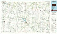
1985 Map of Council Grove
USGS Topo · Published 1985About this map
Council Grove serves as the central hub of this Kansas landscape, situated at the headwaters of the Neosho River. The mid-1980s terrain is defined by a dense network of water systems and rail lines, with the Council Grove Lake forming a significant reservoir just northwest of the city. To the west, the major rail junction at Herington underscores the region's importance as a transportation corridor, where the Missouri Pacific and St Louis Southwestern routes intersect.
Find a feature on this map
65 named features on this map. Tap any name to fly to it.
Don’t see what you’re looking for? This feature index may not catch every label — zoom into the map to look around manually.
Map Details
Editions of this 1985 Council Grove Map
2 editions found
Other maps of this area

1885 · Eskridge
USGS Topo · 1:125,000

1885 · Burlington
USGS Topo · 1:125,000

1886 · Junction City
USGS Topo · 1:125,000

1888 · Emporia
USGS Topo · 1:125,000

1889 · Burlingame
USGS Topo · 1:125,000

1889 · Newton
USGS Topo · 1:125,000

1889 · Wamego
USGS Topo · 1:125,000

1889 · Junction City
USGS Topo · 1:125,000

1889 · Abilene
USGS Topo · 1:125,000

1889 · Parkerville
USGS Topo · 1:125,000